Weather Flow Tempest Weather Station #118478
33.91 °N, 78.13 °W
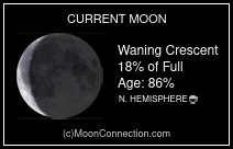
Scroll the image for additional Weather data. Lunar phase, percent illumination and age. Click on the moon to open a page for additional lunar data.
powered by Weatherflow Tempest
Tidal schedule for the Lockwood Folly River inlet at the Point at Oak Island. Data displayed provides relative peak high and low tides in addition to high and low tide times and daylight time on the graph. Click on the image to open another page with additional tidal data.
The Frying Pan Shoals are a line of shallow sandbars extending from the southeastern tip of Bald Head Island (the actual Cape Fear) southward for more than 28 miles into the Atlantic Ocean.
Doppler Weather Radar feed from WeatherUnderground with time loop precipitation movement. Click on the Radar display to open the Radar page in WeatherUnderground for more display options.
The Frying Pan Shoals are a line of shallow sandbars extending from the southeastern tip of Bald Head Island (the actual Cape Fear) southward for more than 28 miles into the Atlantic Ocean.
Made with
Mobirise.com